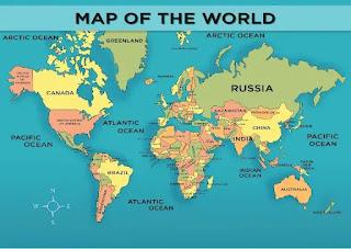
Activity 15 l The World Map and The Tectonic Plates
THE WORLD MAP
AND
TECTONIC PLATES
PHOEBE MARIE BOHOL 10-DILIGENCE
Maps of the world usually concentrate on either political or physical elements. Territorial boundaries and human settlement are highlighted on political maps. Mountain ranges, soil types, and land use are all depicted on physical maps. Not just the surface, but also the underlying rock, fault lines, and subterranean formations are depicted on geological maps. Color hue and intensity are used in choropleth maps to contrast disparities across regions, such as demographic or economic data.
The many projections of the planet represent a variety of technical and aesthetic objectives for globe maps. World maps are also unique in that they require worldwide knowledge to create. Before the European Renaissance, no useful map of the world could be made because no culture knew more than half of the planet's coastlines, let alone its interior areas. Since then, new information about the earth's surface has been collecting, and it continues to do so now.For more information about The World Map and Tectonic Plate Map, watch the Video;
Process Question:
1.) What part of the world that you expected volcanoes are present and why?
-Many of the volcanoes are located along the Pacific Rim in what is known as the "Ring of Fire." In the United States, volcanoes in the Cascade Range and Alaska (Aleutian volcanic chain) are part of the Ring, while Hawaiian volcanoes form over a 'hot spot' near the center of the Ring. There are 169 potentially active volcanoes in the United States.
2.) What part of the world where no presence of volcanoes and mountains are expected and why?
-The mainland is not known for are active volcanoes, which can also be categorized as dormant or extinct. Even though Australia is home to nearly 150 volcanoes, none of them has erupted for about 4,000 to 5,000 years. The lack of volcanic activity is due to the island's location in relatiin to a tectonic plate. Since the mainland of Australia is situated in the middle of the Indo-Australian Plate, it's removed from any major geological faults.
3.) What part in the world the most numbers of Volcanoes are present and why?
-Indonesia, volcanoes that form as a result of subduction zones between the Eurasian and Indo-Australian plates dominate Indonesia's landscape. Together with the Philippine volcanoes, the latter group forms a volcanic arc. Mount Merapi on Java is the most active volcano.


Comments
Post a Comment